 Lake Nakuru is a very shallow strongly alkaline lake 62 square km in extent. It is set in a picturesque landscape of surrounding woodland and grassland next to Nakuru town. The landscape includes areas of marsh and grasslands alternating with rocky cliffs and outcrops, stretches of acacia woodland and rocky hillsides covered with a Euphorbia forest on the eastern perimeter.
The lake catchment is bounded by Menengai crater to the north, the Bahati hills to the north east, the lion hill ranges to the east, eburu crater to the south and the mau escarpment to the west. Three major rivers, the njoro, makalia and enderit drain into the lake, together with treated water from the town’s sewage works and the outflow from several springs along the shore.
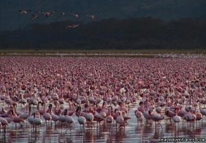
Lake Nakuru was first gazetted as a bird sanctuary in 1960 and upgraded to National Park status in 1968. A northern extension was added to the park in 1974 and the lake was designated as a Ramsar site in 1990. The foundation of the parks food chains is the cyanophyte spirulina platensis which can support huge numbers of lesser flamingo.
Nakuru National Park is located in Central Kenya, 140km north-west of Nairobi, in Nakuru District of the Rift Valley Province. It covers an area of 188 square km. The climate ranges from Cold, Hot and Humid, Hot and Dry. Annual rainfall is 965mm.
Major attractions
- Flamingo (Greater and Lesser) and other water birds including a variety of terrestrial birds numbering about 450 species in total,
- Mammals: 56 different species including white rhinos,
- View-points: Lion hill, Baboon cliff and Out of Africa,
- Hills: Enasoit, Honeymoon, Lion hill ridge etc,
- Waterfalls: Makalia,
- Unique vegetation: About 550 different plant species including the unique and biggest euphorbia forest in Africa, Picturesque landscape and yellow acacia woodlands.
Activities
- Game viewing,
- bird watching