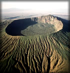
 The name Longonot is derived from the Masai word Oloonong’ot meaning mountains of many spurs or steep ridges. Longonot park covers 52 square km most of it being occupied by Mt. Longonot a young volcano rising to 2,776 meters above sea level. The sides of the mountain have beautiful V-shaped valleys and ridges. The stony soils have little vegetation but the crater has an impenetrable forest.
Climate:
The climate is hot and dry. Mean annual rainfall is between 510 to 760mm. Rainfall reliability is poor and unpredictable. The annual mean maximum temperature is usually between 26 to 30c.
How to get there
The park is accessible via tarmac road from Nairobi (90 kms). Due to the nature of the terrain Mt Longonot has no roads and visitors hike to the top and rim of the crater.
Major attractions
- Extinct volcano and crater forest,
- Scenic Landscape,
- Views of lake Naivasha and
- The Great Rift Valley.