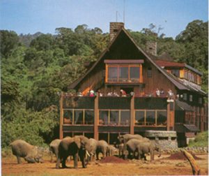
 The Aberdare National Park is Located in the central highlands, west of Mt. Kenya, and is 767 squqre km. From the waterfalls, walks in the moorlands, Twin Hills, Elephant Hills to the Table mountains offers some of the major attraction sites in the Arbaderes. The National Park lies mainly above the tree line running along the 10,000ft contour with some forest and scrub at lower altitude in the ‘salient’ area near Nyeri with the boundary running down to the 7000ft contour. The park is 160 km from Nairobi via Nyeri and Naro Moru on the eastern side, there is also an airstrip available.
The Aberdares are an isolated volcanic range that forms the eastern wall of the rift valley, running roughly 100km north south between Nairobi and Thomsons Falls. There are two main peaks, Ol Donyo Lesatima (3,999m) and Kinangop (3,906m) separated by a long saddle of alpine moorland at over 3,000m. The topography is diverse with deep ravines that cut through the forested eastern and western slopes and there are many clear streams and waterfalls.
The unusual vegetation, rugged terrain, streams and waterfalls combine to create an area of great scenic beauty in the National Park. The park is surrounded by a predominantly indigenous forest, whose management is under an MoU between KWS and the Forest Department.
Climate
Mist and rain occur throughout much of the year, with precipitation varying from around 1000mm yearly on the north western slopes to as much as 3000mm in the south east. Heavy rainfall occurs through most of the year.